Autodesk AutoCAD Civil 3D 2023 Full | ถาวร ออกแบบงานก่อสร้าง
ดาวน์โหลดโปรแกรม Autodesk AutoCAD Civil 3D x64 ตัวเต็มถาวร โปรแกรมออกแบบงาน 3D ด้านวิศวกรรมโยธา ช่วยเพิ่มประสิทธิภาพการทำงาน
Autodesk Autocad Civil 3D คืออะไร
Autodesk AutoCAD Civil 3D เป็นโปรแกรมออกแบบงาน 3D ด้านวิศวกรรมโยธา สำหรับทุกคนที่ทำงานด้านวิศวกรรมโยธา เพื่อหางานที่เหมาะสม ไม่ว่าจะเป็นกระบวนการสำรวจหรือการออกแบบถนน ท่อระบายน้ำ เขื่อน และวัตถุปริมาตรอื่นๆ โปรแกรมนี้มีคุณสมบัติที่เหมาะสมในการออกแบบงานก่อสร้างทุดรูปแบบ เป็นซอฟต์แวร์ที่ใช้ในการออกแบบและจัดการกับโครงการสาธารณสุขและพื้นที่พัฒนา ซึ่งเน้นไปที่งานออกแบบและวางแผนทางเทคนิค 3 มิติ โดยเฉพาะการออกแบบถนน, ทางรถไฟ, การระบายน้ำ, การทำแผนที่ที่ถูกซึ่งมีความจุใจ โดยเฉพาะในงานที่เกี่ยวข้องกับการสร้างสิ่งก่อสร้างที่ใช้ในการขนส่ง เช่น ถนน, ทางรถไฟ, ทางเดิน, สะพาน, การระบายน้ำ, และการจัดการน้ำ โดยซอฟต์แวร์นี้มีความสามารถในการสร้างและแก้ไขแบบจากแนวคิด 2 มิติ เป็น 3 มิติ ทำให้ผู้ใช้สามารถวางแผนและจัดการโครงการทางวิศวกรรมได้อย่างเป็นระบบและมีประสิทธิภาพ
คุณสมบัติของ Autodesk AutoCAD Civil 3D
- ช่วยในการออกแบบถนน, ทางรถไฟ, สะพาน, ทางเดิน, และโครงสร้างพื้นฐานอื่น ๆ ที่ต้องการการวางแผนทางเทคนิคในมิติ 3 มิติ
- รองรับการนำเข้าข้อมูลจากการสำรวจและการวิเคราะห์ข้อมูลที่ได้จากภูมิประเทศ
- ระบบฐานข้อมูลที่เชื่อมโยงกับโครงการที่ใช้ในการจัดการข้อมูลทางเทคนิคและการแก้ไข
- ช่วยในการวางแผนและการจัดการระบบการระบายน้ำและการจัดการน้ำในโครงการ
- สนับสนุนการจัดการความสูงของพื้นที่และการสร้างโครงสร้างที่เกี่ยวข้องกับการเปลี่ยนแปลงระดับดิน
- มีเครื่องมือในการสร้างและจัดการข้อมูลทางสถิติที่ใช้ในการวิเคราะห์และการวางแผน
- มีเครื่องมือในการจัดการการเขียนแบบที่ช่วยให้ผู้ใช้สามารถสร้างและแก้ไขแบบการทำงานได้อย่างมีประสิทธิภาพ
- รองรับการเชื่อมต่อกับฐานข้อมูลที่ใช้ในการจัดการโครงการและข้อมูลเชิงพาณิชย์ที่เกี่ยวข้อง
Features
- Optimized performance for DREF elements
- Add custom data to Civil 3D object labels by using property sets
- Use preliminary design models within Civil 3D
- Bring new roundabout designs into Civil 3D
- Link topography from Civil 3D to Revit
- New features for rail design
- Curves and transition spirals alignment
- Customizable user interface with optimization and customization
- Design and build a variety of roads, passages, tunnels and other sections of civil engineering projects
- Perform repetitive design actions dynamically and precisely
- Document all stages of construction
- Having a standardized database of various components of civil engineering projects
- Perform a variety of geological and geological surveys and analyzes
- Ability to work in groups and to share and update project information
- Features oil and gas pipeline route design
- Enhance structural and civil design collaboration
- Offset profiles are more accurate with support for vertical curves
- Expanded corridor capabilities with more than 60 additional subassemblies
- Represent 3D solid objects more accurately with more control over visual properties
- Meet more design standards with additional fittings and appurtenances
- 3D project capability to better understand and visualize and make necessary corrections and optimizations
- Enjoy AutoCAD Map 3D software mapping capabilities
- Support for GPS tools and their positioning information
- Increase speed and accuracy as well as reduce project costs
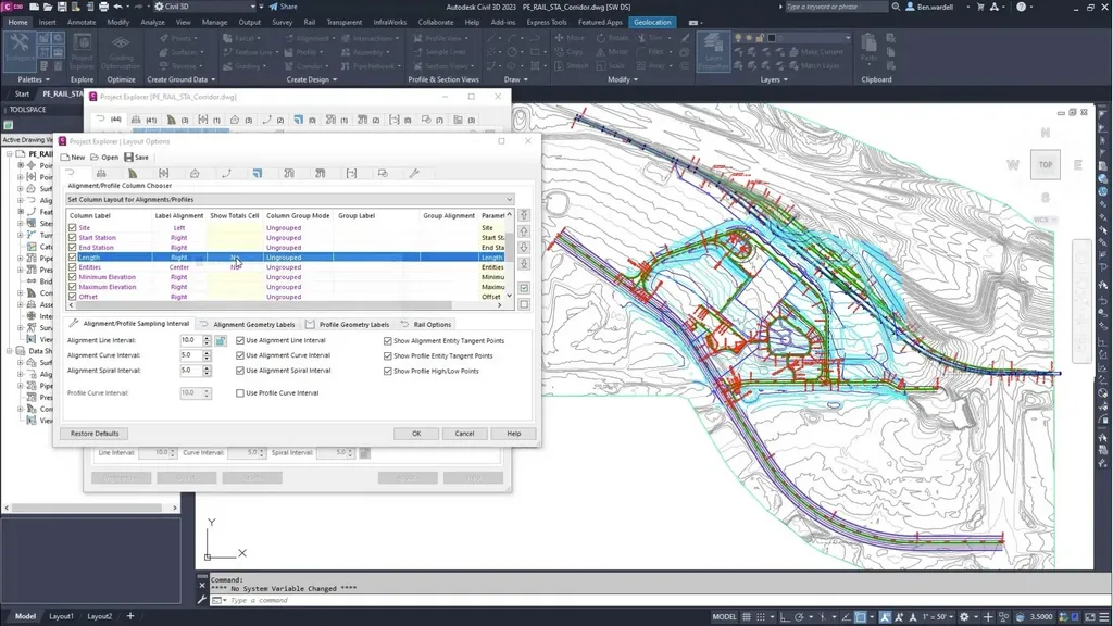
ภาพตัวอย่าง (Screenshot)

ความต้องการของระบบ
- ระบบปฏิบัติการ: Windows 11 / 10 / 8.1 / 7 (64-bit)
- หน่วยความจำ (RAM): 4 GB (8 GB แนะนำ)
- พื้นที่ว่างในฮาร์ดดิสก์: 10 GB ขึ้นไป
ข้อมูลไฟล์
- ผู้พัฒนา: Autodesk
- ประเภทใบอนุญาต: Shareware
- ภาษา: รองรับหลายภาษา
- รูปแบบไฟล์: .zip
- ขนาดไฟล์: 4.4 GB
- เวอร์ชัน: 2023
- วันที่อัปเดตล่าสุด: 15/4/2022
- เซิร์ฟเวอร์ดาวน์โหลด: Send
ข้อมูลสำคัญก่อนดาวน์โหลด
- วิธีดาวน์โหลด: ดูขั้นตอนการดาวน์โหลด
- รหัสแตกไฟล์: ไม่มี
Disclaimer
เว็บไซต์นี้ไม่ได้เป็นเจ้าของลิขสิทธิ์ของซอฟต์แวร์ ลิงก์ทั้งหมดเป็นแหล่งภายนอก เนื้อหานี้จัดทำขึ้นเพื่อการแนะนำซอฟต์แวร์เท่านั้น ผู้ใช้ควรตรวจสอบเงื่อนไขจากผู้พัฒนาโดยตรง
โปรดระมัดระวังโฆษณาที่อาจเด้งไปยังหน้าอื่น และตรวจสอบชื่อไฟล์รวมถึงขนาดไฟล์ก่อนดาวน์โหลดทุกครั้ง


